Length/Type: Approximately 5.5 miles one way, out-and-back; Difficulty: Easy (slight grades and wide, crushed-gravel trailbed; moderate if traveling all the way to the end of the trail and returning); Other Considerations: this is a multiuse trail open to both mountain bikers and hikers. Horses are not allowed, and the only trailhead is located at the trail’s northern end (no vehicle access is available at the trail’s southern end at the Clinch River). A smartphone-based guide for this trail is also available here.
It’s a testament to the natural beauty of Southwest Virginia that the Guest River Gorge doesn’t get more respect. In another state and in another context, the 5-mile-long Guest River Gorge would be a likely centerpiece for a state park itself. But thanks to the overwhelming popularity of the Virginia Creeper Trail some 40 miles to the east, the Gorge and its companion 5.5-mile multiuse trail receive little attention outside of local residents in Wise County and adjacent communities.
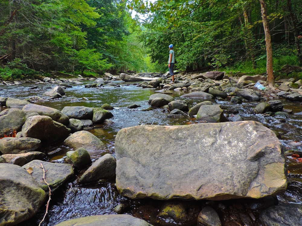
Perhaps that’s all for the best, though. Very much an overlooked cousin to the Virginia Creeper, the Guest River Gorge Trail is similar in structure – it has the same crushed-gravel trailbed – and shorter in length yet not lacking at all for scenery. And here’s the best part: you’re likely to have it all to yourself. The Gorge itself is a spectacular chasm carved some 400 feet into the southern face of Stone Mountain by the Guest River, a classic Appalachian headwater stream arising high on the Appalachian Plateau. Surrounded on nearly all sides by the Jefferson National Forest, the Gorge’s high cliffs and rugged class IV-V rapids take on a wilderness feel that is hard to find in the Cumberland Mountains and west of I-81. Black bears are not an uncommon sight deep within the Gorge, and numerous side canyons and their associated waterfalls beg for further exploration.
The Hike
The trail itself follows the former path of the Interstate Railroad, a line running from Miller Yard near Dungannon, Virginia to the Town of Coeburn some 1,000 feet higher on the Plateau. Just as the river followed the path of least resistance off of the mountain, this rail line did the same, providing a convenient if not rugged route to the more easily navigable Great Valley to the east. The line was abandoned and fell into disrepair in the latter half of the 20th century before a group of dedicated citizens worked with the USDA Forest Service to develop a trail along the railroad’s former route. Today, the trail and a sizable parking area exist within the Gorge, and the Guest River has been designated a Virginia Scenic River for its incredible natural beauty.
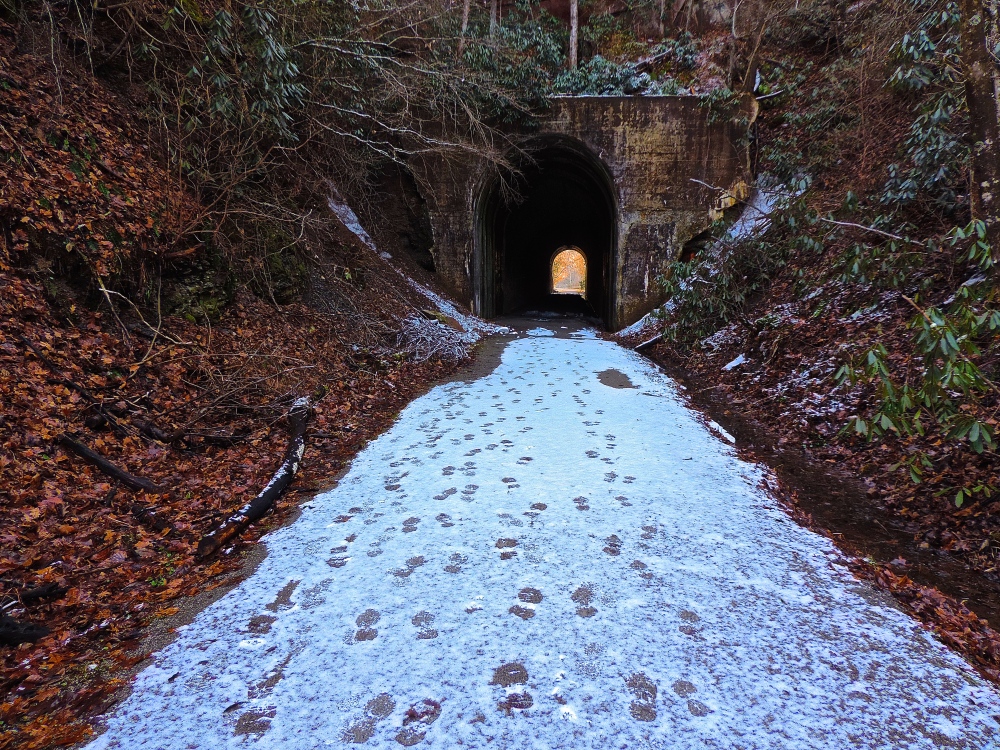
The handicapped-accessible trail begins at an obvious kiosk located on the south end of the parking area, winding down on a series of gentle switchbacks to the former railbed just below. From here, the trail turns right (downstream) along the Guest, whose rapids can be heard just out of sight through a dense forest of rhododendron and hemlock. At 0.4 miles, the trail passes a seasonal waterfall on the right that spills over the lower rim of a scenic box canyon opening above the trail. Just beyond this waterfall, the trail enters the Swede Tunnel built in 1922 to allow for the passage of the Interstate Railroad.
The trail enters the gorge proper just beyond the south portal of the tunnel, crossing the Guest on the first of three wooden trestles at mile 0.5. Views can be had of the Guest both upstream and downstream from the trestle, featuring the first glimpse of rapids and sluices that will only get larger and more dramatic as the trail winds deeper into the Gorge. Beyond the trestle, the trail stays mostly above the river until it crosses the second, much shorter trestle at mile 1.5. Along the way, the trail passes a seasonal pool to the left where an abundance of frogs can be seen and heard from early spring to fall.
Make sure to stop for a moment at the second trestle and look to the left, upstream along Crab Orchard Branch. A small tributary of the Guest, Crab Orchard Branch spills over the lip of the gorge just upstream from the trestle, culminating in an incredibly scenic waterfall that can be viewed from the trestle’s deck and would be the destination of a hike in its own right. This will be the first of at least four such smaller streams that will meet the Guest along the trail’s route, nearly all with scenic waterfalls. A short side trail leads from just before the trestle up to the waterfall on Crab Orchard Branch and seems to continue beyond, although this trail enters private property just above the falls. Do not trespass beyond the falls or follow any side trails out of the Gorge that lead away from the main trail.

Continuing downstream on the main trail from this second trestle, the Gorge begins to only get deeper and more scenic. The trail passes along the opening to a shallow cave just below the trestle and at 1.9 miles passes a noisy tributary that enters the Guest on the opposite side of the Gorge. When leaves are off of the trees in winter, careful examination near this spot can reveal a scenic waterfall dropping through a narrow notch in the sandstone on the other side of Gorge, not all that unlike a miniature version of North Carolina’s Linville Falls in appearance. Just beyond the this point, the trail passes below a dramatic, open cliffline at mile 2.0 and crosses yet another tributary stream and its cascades at mile 2.3.
This theme of alternating between open clifflines and cascading side streams continues for the next two miles as the Gorge continues to the get deeper and more scenic. Clifflines along this stretch continually get higher, with each side canyon becoming wilder and more rugged in appearance. Just before mile 3.0, the trail swings around a long bend in the river, offering another beautiful long-range view upstream. This particular viewpoint seems more akin to some of the wildernesses along the Blue Ridge of North Carolina and Tennessee rather than a locale in the Coalfields.
The trail continues on this pattern past mile 4.0 until it passes one of the only signs of civilization in the Gorge beyond the trail itself at mile 4.7: a long, curious concrete wall build several yards out into the river. This wall was originally built as a flood control measure to prevent undercutting erosion below the original trailbed. The river backs up along this wall, providing a buffer of sorts between the impacts of frequent flash floods and the steep wall of the Gorge. If you are lucky enough to travel the trail after a heavy rainfall event, you will likely witness the power of water in the Gorge firsthand: at the peak of a flood event, the Guest River can become a thundering, intimidating torrent of water screaming down its near 1,000-foot drop off of the Plateau.
Beyond the retaining wall, the trail continues downstream to its third and final trestle at mile 5.5. A house located on the opposite riverbank just before this point provides a sign that the trail is finally leaving the wild and rugged depths of the Gorge. Just beyond the trestle, the trail ends in a T-intersection with the Clinchfield Railroad. Just beyond it, the Clinch River flows on its path down the westernmost arm of Virginia’s Valley and Ridge Province and absorbs the flow of the Guest just past the mouth of the Gorge. Enjoy the view, but don’t wait too long – there is no lower trailhead for the Gorge, meaning that your only option is to retrace your steps on the return trip…climbing back up the elevation you have just lost.
Nature Notes
As should go without saying for anyone that has spent time in the Gorge, the Guest River is a testament to the power of water in the Appalachian Mountains. The river itself has a big enough watershed and enough length prior to entering the Gorge to pick up a large volume of water, and it’s this increased flow that has allowed the Guest to cut such a dramatically deep and wide gash in the southern face of the Appalachian Plateau. This gorge, in fact, dwarfs similar nearby gorges found along Little Stony Creek and the Devil’s Fork, both similar in structure but not nearly as large, thanks to being crafted by smaller streams.
This power is on full display between mile 1 and mile 2 in the Gorge. Here you can find several dramatic boulders to the left of and just above the trail, some easily the size of a large house or small office building. Upon closer examination, these rocks become not just boulders but large segments of the lip of the Gorge dislodged over time through the constant eroding power of water and the pull of gravity. Some of these boulders have even tumbled their way down into the actual riverbed itself, forming dramatic rock gardens that the Guest braids through on its way downstream. The thought of such a large mass of rock breaking free and tumbling down into the Gorge is enough to give a person pause as they wind through its depths.

As if that wasn’t enough, the eroding power of water has also had consequences for wildlife within the gorge. At least one large raven nest can be seen in cliffs high above the trail near the midpoint of the trail, and rare species such as the Green Salamander actually use the deep crevices of rock in the Gorge’s cliffs as habitat, periodically emerging and climbing into the forest canopy to forage. Even the present-day action of water drives the Gorge’s wildlife: in special locations in the Gorge, the scoured boulders along the riverbed provide a home to the rare Virginia Spiraea, a federally-protected plant that requires these water-scrubbed habitats to survive.
Directions: From the junction of VA-72 and US-58Alt in Coeburn, follow VA-72 south for approximately 5 miles to the signed entrance to the Guest River Gorge on the left. Turn left here and follow the entrance road to its end at the large paved parking area and trailhead.

One Comment Add yours