Length/Type: Approximately 4.0-5.0 miles total, out-and-back (multiple turnaround points exist along cliff system); Difficulty: Moderate to Difficult (some steep climbs, poor footing in several stretches); Other Considerations: The road leading to the trailhead is closed seasonally, most often January-March or when weather conditions prevent safe travel. A detailed trail map is available via the park’s website.
The 44 mile-long Pine Mountain Trail, which runs the border between Kentucky and Virginia in the far eastern and southwestern corners of each state, has a slew of fantastic scenery all along its length. But arguably the best scenery anywhere along the trail occurs in its northernmost 13 miles from Birch Knob to its terminus in Elkhorn City, KY at Breaks Interstate Park. Along the way, the trail passes a near-constant series of rugged clifflines and overlooks that are easily some of the best scenic features in all of central Appalachia. Roll in a smorgasbord of rare species and habitats such as high-elevation wetlands, and the Birch Knob section of the PMT becomes one of the most unique hiking experiences in the region.
The Birch Knob Trailhead is not easy to reach, but it’s worth visiting even if you don’t hike a step on the PMT. That’s because this trailhead is located at the Birch Knob Tower, an open-decked viewing platform allowing 360-degree views from the summit of Birch Knob – at 3,144 feet the highest-elevation spot found anywhere along Pine Mountain’s 100+-mile length. Once the site of a firetower, the Knob now has a unique viewing platform, constructed by the USDA Forest Service and reached by a labyrinthine series of metal steps climbing the upper pinnacle of Birch Knob, which is crested with jumbled sandstone boulders. From the summit, the Appalachian Plateau spreads to the north into Kentucky, while the high summits of Mt. Rogers and Whitetop (the two highest mountains in Virginia) are visible on clear days amid a jumble of other peaks to the south. As scenic as Birch Knob is, though, it’s just the appetizer to a collection of even more dramatic peaks found just a handful of miles (and a relatively easy dayhike) down the PMT.

The Hike
The PMT leaves the northeast corner of the Birch Knob parking lot and quickly swings to the north of and below the knob’s summit (note that the short roadbed leading to Birch Knob’s tower heads the opposite direction, to the south). A hundred yards or so down the trail, the PMT passes a high spring and large sandstone boulder that appears to have dislocated from Birch Knob’s summit at some point high above. An informational sign at this point provides a brief overview of the mountain, erroneously identifying Birch Knob as the highest point on Cumberland Mountain – instead, Cumberland Mountain is the next major ridge to the south from Pine Mountain and reaches elevations nearly 1,000 feet higher than Birch Knob.
The PMT then rolls along the contour of the ridge and climbs to a short spur ridge at 0.3 miles. This spot is home to the Birch Knob Shelter, one of several top-notch backcountry shelters built at intervals along the length of the trail. The PMT passes right in front of the Birch Knob Shelter – complete with a privy in the woods a short distance behind it – and travels a short distance to a signed junction with a spur trail. This spur heads approximately 0.3 miles down a hollow to Jenny Falls, a low but impressively rugged drop on a headwater stream cascading off of the south face of Pine Mountain. The spur trail is short but rugged, dropping steeply from the main trail, but is worth the trip when streams are running freely.
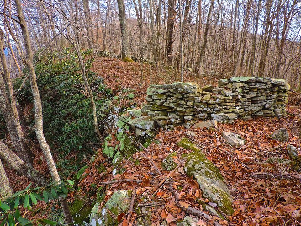
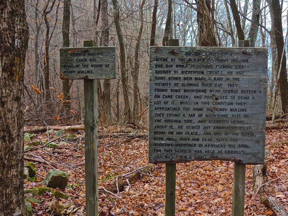
From its junction with the spur trail to Jenny Falls, the PMT descends 0.2 miles to Dutton Bottom. Not a “bottom” in the common usage of a low, flat area along a stream, Dutton Bottom is instead a high, flat area located in a saddle on Pine Mountain just to the east of Birch Knob. This area is particularly scenic, with Pine Mountain dropping steeply off to the north and a high spring located below the Bottom and to the west. A series of signs detail the human history of this spot, which involves (without spoiling the story) moonshine, murder, and the remains of an old homestead, the latter of which can still be viewed in the form of rock piles scattered around the Bottom. The photo below provides a more detailed overview of the history of the site for those that are interested.
The PMT then leaves Dutton Bottom and begins a sinuous dance with the crest of the ridge on its way to Blowing Rock Gap, located some 0.9 miles away. This stretch of trail is actually illustrative of one of the more frustrating parts of the Pine Mountain Trail: an occasional lack of grading and fitting of the trailbed to the contour of the ridge. Along its entire 44-mile length, the PMT is infamous for short but incredibly steep pitches of trail that inexplicably dive from the ridgeline 100-200 vertical feet or so down the mountain, only to climb right back up again to the original elevation. This is easily understood in some places where steep cliffs or other obstacles stand in the way, but occasionally the trail makes one of these dives with no easy explanation.
That’s the case here in the stretch between Dutton Bottom and Blowing Rock Gap. The PMT initially leaves Dutton Bottom by climbing steeply at times along the ridge and eventually approaching a low knob on the Pine Mountain ridgeline. From here, though, the trail swings to the south side of the mountain, diving directly perpendicular to the contour of the ridge in an incredibly steep pitch that walks more like a landslide scarp than a trail and appears to follow an old roadbed or ATV trail. Erosion has predictably ramped up along this stretch, creating a rutted, muddy mess during some parts of the year. At any rate, the minor annoyance here is worth it, as the views ahead at the turnaround for this hike are a fine reward for the effort. The trail leaves the hollow mentioned above and climbs steeply again through rhododendron, entering Blowing Rock Gap approximately 1.4 miles from the starting trailhead. Signs here provide some information on the history of the gap, once a route of passage over the mountain to link Kentucky and Virginia.
The more sensible climbing resumes at Blowing Rock Gap. The PMT ascends, never straying far from the ridgecrest, to a sharp left turn marked by bright green arrows painted on the bedrock at 1.8 miles. A blue blazed trail heads downhill along open rock at this point, leading in a short distance to a maze-like formation of moss-covered boulders. (The trip is short and well worth it, although the blue-blazed trail continues onward down the mountain, presumably to private land.) The PMT continues on from this junction and doglegs out to the beginning of the most scenic stretch of this hike just beyond.
It is honestly difficult to put in writing how scenic the trail becomes over the next half-mile or so. The trail here becomes less of a woods walk and tracks right along the uppermost lip of a long series of cliffs that fall off precipitously to the north from Pine Mountain’s summit at heights that easily surpass several hundred feet in places. This area is so scenic, in fact, that there are likely few stretches of maintained trail anywhere in the southern and central Appalachians passing alongside a cliff system more open, rugged, and sustained than this one. Although views from the cliffs are not always continuous, large topknots of sandstone jut out every few yards and provide incredible vantage points over eastern Kentucky’s Appalachian Plateau. The long ridgeline of Pine Mountain continues on at each of these overlooks, with seemingly no end in sight.


After passing the first few vantage points along this cliff system, the PMT appears to descend away from the cliffs. Be sure to not be fooled into turning around here, as the trail regains the cliffline beyond this quick descent and reaches several more vistas, even walking directly on the lip of the cliff on open rock during one particularly scenic stretch. About midway through this stretch, the PMT passes Blowing Rock itself, called “The Blow Hole” by locals. Blowing Rock is actually a small sandstone arch, carved presumably by the eroding forces of wind over the millennia. This arch, though, actually occurs on the back end of the cliff’s edge, forming a bizarre passageway below, back, and through the main cliff line to its open face to the north. When winds angle up the mountain from the north and northeast, they blow almost vertically up through the arch, creating a wild “chimney-like” effect on the mountainside. (The Nature Notes section below details why this effect occurs here.)

Shortly after Blowing Rock, the PMT again leaves the cliffs and descends, this time for good. The trail climbs down and around the final pitch of the high cliffs in this section, reaching a blue-blazed spur that forms a great turn-around point for the hike. It’s easy to find yourself walking back and forth along the preceding cliffline, though, especially considering the complexity of the outcrops and vistas at this site.
Nature Notes
Blowing Rock, also known as The Blow Hole, is the punctuation mark on the high, panoramic series of cliffs featured near the turnaround point for this hike. But what makes Blowing Rock blow? In reality, this is not the only “blowing rock” in the southern and central Appalachians. From this arch on Pine Mountain to the more famous overlook that gives Blowing Rock, North Carolina its name, there are multiple points along the Appalachians where winds seem to inexplicably switch direction to blow vertically up the mountainside.
So, what causes this effect? The characteristic, vertical winds of blowing rocks most often occur when wind angles hard and against a vertical or near-vertical slope, just like the one featured here on the PMT. When this happens, winds can be deflected and rise quickly up and over the cliff-face, breaking at what seems like a vertical angle over the ledge to rise above the mountain’s summit. Here at the PMT’s Blowing Rock, the sandstone arch mentioned in the hike description above only serves to magnify this effect, forming a “chimney” of sorts to funnel rising winds as they scream up and over the cliff.

Most typically, features like Blowing Rock form where a mix of ingredients are in place: (i) the steep slopes mentioned above and (ii) prevailing, occasionally strong winds that often angle directly against the mountainside. That’s the case here on Pine Mountain, as storms coming in from the north and west are often aimed directly at the ridge. And since Pine Mountain forms virtually the first spot above 3,000 feet beyond the Great Plains that storms encounter as they head towards the Appalachians from the west, there are few features on the landscape to block or weaken approaching gusts.

A similar phenomenon occurs at North Carolina’s Blowing Rock. Although that overlook lacks the odd arch formation seen here on the PMT, it also is one of the first high-elevation spots that winds reach as they head up from the Piedmont and Coastal Plain regions to its south and east. That isn’t the only similarity between the blowing rocks in North Carolina and Kentucky, though. These types of formations and their vertical winds also share bizarre legends: snow has reportedly been seen falling upward at North Carolina’s Blowing Rock, carried by winds from below, while legend has it that hikers have had hats blown off their heads at the PMT’s Blowing Rock, only to get carried back to them on winds rising from the valley. Regardless of these legends’ truth, the unique meteorological traits found at both sites unite two incredible features in our mountains, despite being located nearly 100 miles apart.
Directions: From the intersection of VA-83 and SR-631 just west of downtown Clintwood, Virginia, travel approximately 3.0 miles to VA-611, which angles uphill and to the right just across the bridge over the Pound River. Turn onto VA-611 and follow it 2.3 miles to dirt-gravel Birch Knob Road on the left. Take this road 5 miles to its end at the trailhead parking area atop Birch Knob.
